

St. Pete Beach, Florida Maps
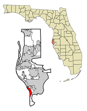 St. Pete Beach is located at 27°43′29″N 82°44′31″W / 27.72472°N 82.74194°W / 27.72472; -82.74194 (27.724587, -82.741850).
According to the United States Census Bureau, the city has a total area of 51.5 km² (19.9 mi²). 5.8 km² (2.2 mi²) of it is land and 45.7 km² (17.6 mi²) of it (88.68%) is water.
St. Pete Beach occupies the entire space of Long Key, a barrier island at the east central edge of the Gulf of Mexico. Three bridges lead into the city, connecting it to Treasure Island (Blind Pass Bridge), South Pasadena (Corey Avenue Causeway)and the Bayway Isles area of St. Petersburg (Pinellas Bayway).
The main north-south routes are Blind Pass Road and Gulf Blvd. The main east-west routes are 75th Ave./Corey Causeway and the Pinellas Bayway.
|
View Larger Map |
Links to other maps
St. Pete Beach and Tampa Bay Nautical Chart